June 8, 2018
 |
| 10:30 PM thinking about being sunset as we leave Cordova area |
 |
| 10:30 PM thinking about being sunset as we leave Cordova area |
It’s been an eventful several days
as we traveled to then from the town of Valdez.
 |
| Tatitlek Village on the way to Valdez |
 |
| Southern terminus of the Alaska Oil Pipeline |
 |
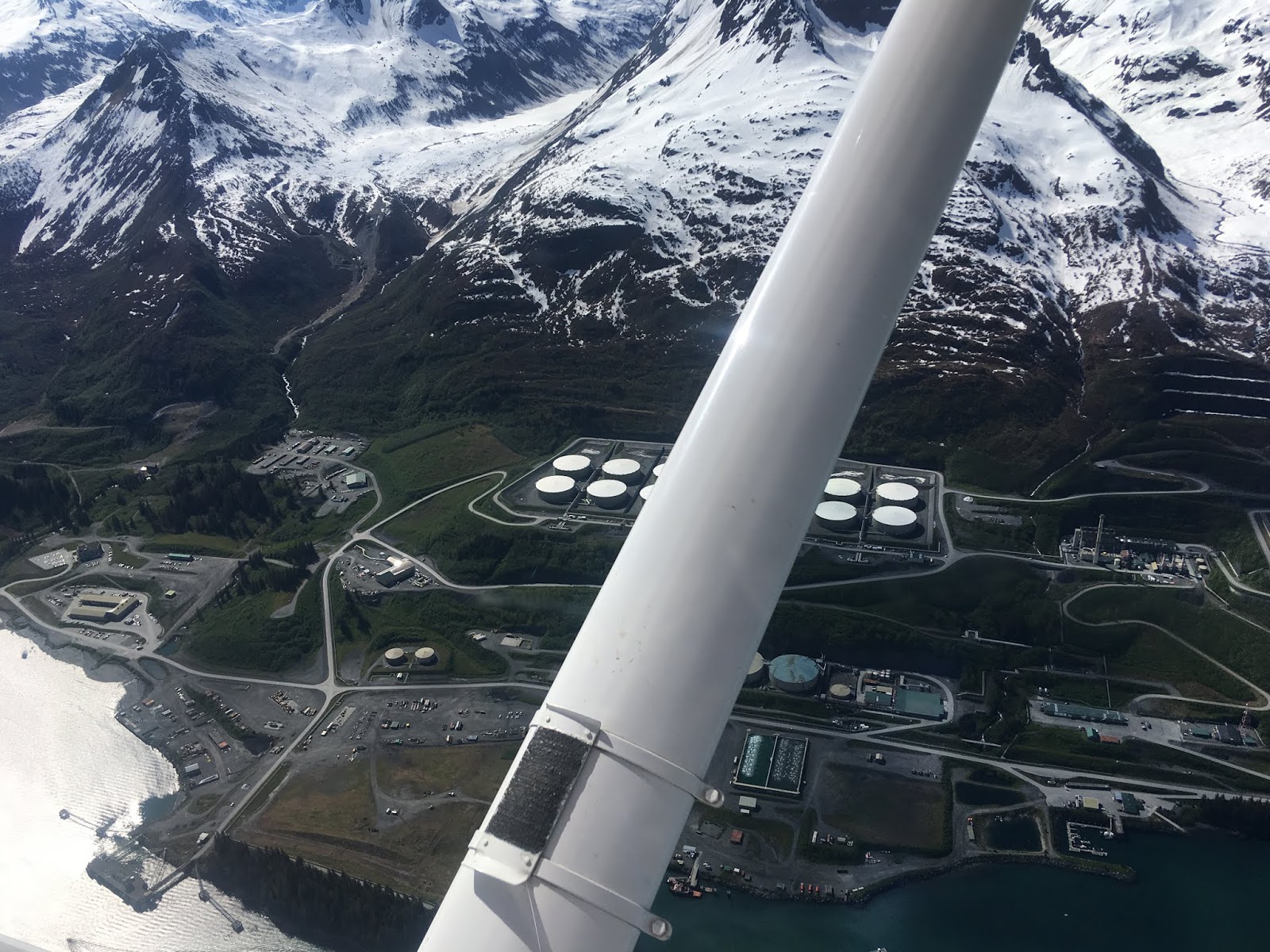
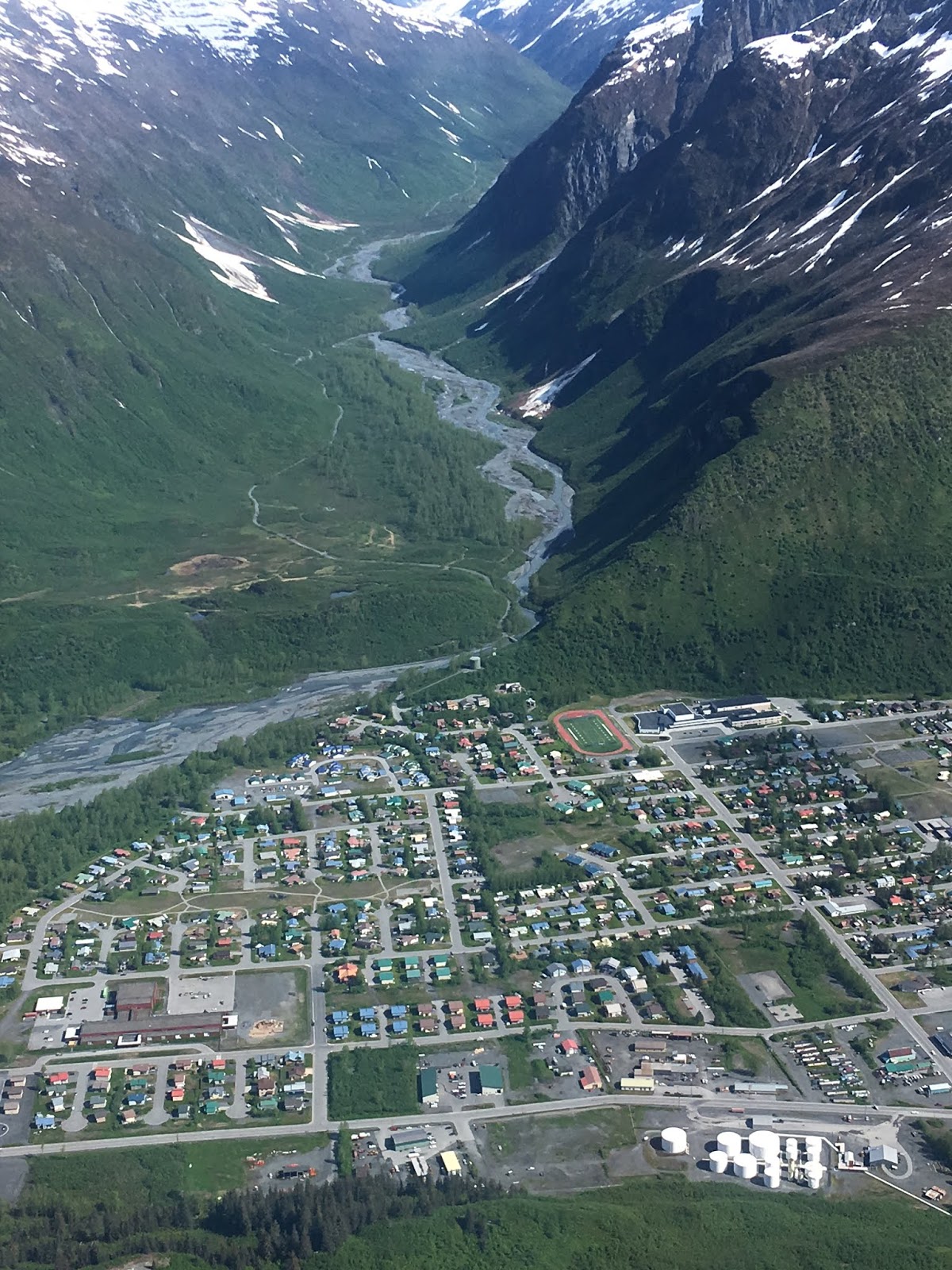
| Valdez from the air |
One our way to Valdez we stopped
and spent a night at anchor in the outer harbor of Shoup Bay State Marine
Park. The park is at the toe of Shoup
Glacier. When a glacier moves forward it
pushes a pile of dirt and rocks (moraine) which often stay and act as a dam as the
glacier recedes. Shoup Glacier has an outer moraine that can be crossed by larger
boats with the central passage about 15 ft deep at low water and an inner moraine about 1 mile further
with a very well defined channel that can be crossed with a small boat on high
tide. The outer moraine defines the bay
as it is pretty much salt water and the inner moraine defines the lake as it is
primarily fresh water. Once you enter
the lake it’s about 1 ½ miles across the lake to the toe of the glacier which
is back a short distance from the beach.
The fjiord leading into the glacier was covered with fresh bright green
growth with the arrival of spring and many waterfalls from the snowfields at
the top. The effect was much like the
opening scenes from the movie Jurassic Park except it was cloudy and cool
rather than hot and muggy. In any case the scenery was amazing. After anchoring in front of one of the public
use cabins with a shore tie as the shelves out from the shores are fairly
narrow with steep drop offs, we waited for the tide to come in and then took
Jarvis in the dingy to visit the glacier toe. We (including Jarvis who seemed
very interested in the glacier for some reason) were in awe and just wished we
could see what the bay would look like on a sunny day.
 |
| Setting for Jurassic Park Ice Age - Shoup Bay State Park outer bay |
 |
| Looking across the lake/lagoon toward Shoup Glacier |
 |
| Jarvis was quite intrigued by the glacier and walked right up on the ice |
 |
| Foot of Shoup Glacier |
 |
| On his way to see the ice |
 |
| Ice cave at the foot of Shoup Glacier |
The next morning we awoke to
perfect blue skies and decided to go back into the lake to check out 2 other
cabins. When we got through the channel
into the lake we saw that a float plane had come in while we were sleeping to
one of the cabins. We offered the couple
in the plane a boat ride over the lake to the toe of the glacier and they were
glad to have the chance to see it. When we were about to land back at their
cabin they offered us a ride in their float plane. Perfect weather, incredible
scenery, and a chance to do something on my bucket list – I couldn’t say
“YES!!” fast enough. They took us
(including Jarvis) for a flight over Valdez and the surrounding mountains and
glaciers. We were able to see the
immense Columbia Glacier from the air and even got a couple photos of Salish
Aire at anchor. The only one with some trepidation
was Jarvis but he seemed to settle in after a bit as he usually does with new
experiences.
 |
| "Hey, would you like a ride in our float plane?" |
 |
| Looking from Shoup outer bay over the moraine to the glacier at the head of the lake/inner lagoon |
 |
| Our ship at anchor |
 |
| Initially Jarvis didn't know what to think but he got used to the ride very quickly |
 |
| Do we get a tax advantage for having the boat used as an airport? |
From Shoup Bay we travelled
through Valdez narrows (after confirming with traffic control that we didn’t
have to compete with any oil tankers) and on to Valdez where we got a nice spot
on the dock. We enjoyed the town that was really gearing up for tourist season
with RV parks and fishing derbies advertised everywhere. I was excited to have a “red meat” dinner of
ribs that tasted great and noted that the Radio Shack store had a forest of ham
radio antennas sticking out of it. The
next morning I met with AL4O “Larry” and we yabbered about radios and boats for
a while. At the end of the conversation
he offered us his truck so we could drive up the Richardson Highway to see the
scenery between town and Thompson Pass.
The pass still had a lot of snow and clouds were low so it was scenic
but not “super wow”. On the other hand
the highway passes through a narrow canyon with several amazing waterfalls that
made the trip well worthwhile.
After we returned the truck we
headed out in somewhat mucky weather to anchor in Sawmill Bay State Marine Park
south of town. We had been settled on
our anchor for about 2 hours when I heard a radio call that sounded very close
including the information that a child was unconscious likely from carbon
monoxide. I yelled at Clarice to grab
the first aid kit and oxygen tank while I grabbed the AED and then we both
headed to the dinghy deck. We normally
take about 20 minutes to launch the dinghy but we believe we had it in the
water and loaded with gear in less than 10 minutes and were on our way to the
only other boat in the anchorage. On
arrival we found a man who was lucid who reported that they had been running
the generator and trying to start one of the engines for about 20 minutes. There was a young boy who was rapidly losing
mentation until when Clarice got to his side within seconds he was
unresponsive. A third adult woman had
been throwing up and was only partially lucid.
I opened doors and windows while Clarice put oxygen on the child and we
were able to have everyone in somewhat better shape by the time the Coast Guard
showed up not much later. The 6 young
men loaded everyone on their boat (including Clarice and I as they didn’t have
the medical expertise we did) and we headed back to Valdez at over 30
knots. When we last saw the family,
everyone was much more lucid and the child was able to walk to the ambulance
with just minor assistance. In looking back our honest assessment is the child
may not have survived had we not been able to respond as quickly as we did.
Clarice decompressed with her sister and our eldest grandson on the phone and I
said a few prayers of thanks. We also
were publically thanked on the radio by the CG and we made sure they knew how
much we appreciated their response as well.
 |
| "Raft" of otters in Sawmill Bay |
June 16, 2018
After the last notes we anchored
for several days as we moved towards the town of Whittier. Our first Anchorage was in a bay connected to
the fjord leading to the Columbia Glacier which we had flown over during our
float plane ride. We were pretty excited
to see the face from the water if the ice flows would allow but didn’t really
have the chance to get close enough as it has receded quite a bit from where
our charts show it to be. In any case the day we arrived we put into a cove
separated from the main fjord only by a shallow moraine. The moraine allowed us
to travel over in our dinghy but kept the many large icebergs away from us. The
first evening we watched a glacier tour boat go quite a way up the fjord and
likely the tourists got some nice photos of the face. The next morning the ice that had been
gathered near the glacier end of the fjord was now spread throughout the length
and we were really glad we had anchored behind the protective moraine. We did take the dinghy and found a path among
the bergs to travel about 2 ½ miles up the fjord to where we could just start
to see the face at which time we turned around as the air was pretty cool
coming off the glacier and icebergs and we were all getting cold.
 |
| An old moraine kept the large icebergs out of our anchorage |
 |
| Oyster Catcher flirting |
 |
| Columbia Glacier from the water |
 |
| Columbia Glacier from the air |
Next we moved to Ester Bay which
is a virtual fairyland anchorage that was a kayak heaven surrounded with open
meadows and mountains on Esther Island.
Entering the anchorage was the first time we have seen a number of
salmon jumping and the local net fishermen tell us the season is finally
picking up.
 |
Ester Bay Reflection |
 |
| Clarice setting a stern tie |
 |
| Ester Bay |
 |
| Esther Bay meadows |
We then picked up some longtime
friends from Anchorage in the town of Whittier and took them to Surprise Cove
Marine Park for the night. The anchorage
is lovely but the surprise turned out to be a rocky bottom that would not hold
an anchor. It usually takes us about 15
minutes to set an anchor securely instead of the hour it took us there. When it did set it held well. The next day the weather turned from lovely
to windy and even the locals indicated it was an unexpected change. To add to
our frustration (we were supposed to be showing Bruce and Tina how smoothly we
had the whole boating thing under control) we discovered water on the bedroom
floor when we returned to the dock.
After pulling everything out from under the beds and lots of mopping and
work with the water vacuum we felt we had things under control but left the
boat in a big mess as we headed into Anchorage with our friends to visit their home
but not before we had to fight with the shore power GFI to get it to stay
connected to keep the batteries up despite the refrigeration drain. (The source
of the water turns out to be a long standing seep from the top of the fresh
water tank when we fill it to the brim – it had pooled and then overflowed when
we used the watermaker and added weight to the port side of the boat – not
terribly hard to fix (we hope) when we decide to take time to work on it.)
The weather in Anchorage was very
warm and sunny. We enjoyed being back in
a large town where we could visit big stores and take in a movie. We really enjoyed catching up on the news
with our friends and they took us to their lakefront cabin on Big Lake north of
Anchorage. Jarvis was pretty happy having
a whole back yard to himself to explore as well.
 |
| Bruce and Clarice paddle on Big Lake north of Anchorage |
 |
| Bruce and Tina's cabin on Big Lake north of Anchorage |
 |
| top to bottom, left to right: Bruce, Tina, Norman, Clarice, Jarvis |
We are now tied up in the Whittier
Marina while a windy rainy storm passes through after having one sunny day when
I was able to hike to scenic Portage Pass.
Whittier itself is a really unique place. Whittier is at the head of a
fjord that happens to be just a short distance from the city of Anchorage with
the small problem of a large mountain blocking the way. Natives and later
everyone from miners to railroad builders used the Portage Pass route over the
mountain and associated Portage Glacier to take a short cut to Anchorage for
many years rather than the very long route down around the Kenai Peninsula and
back up Cook Inlet. With the coming of
WWII the military was very concerned that the primary route to get materials
into the interior of Alaska was via the Port of Seward and then via the Alaska
Railroad which they felt was very vulnerable to attack and challenging in the
winter. The result was that a 2+ mile
train tunnel was bored through the solid rock of the mountain. For many years if you wanted to “drive” into
Whittier you drove onto a flatcar and were brought into town on the train. That
changed when the railroad rules changed and no longer allowed riding in cars on
flatcars so something needed to be done.
The tunnel was then converted so that it now serves cars and trains but
only one way traffic at a time. Outbound
cars and trucks leave on the hour, inbound on the ½ hour and trains when there
are no cars with a rather sophisticated control system.
The town itself is interesting in
that everyone who lives here lives in one concrete high-rise building.
There are two huge cold war era concrete
buildings one of which is an abandoned military headquarters and the other
which was military housing.
The housing
building now has the city offices, a store, and the post office on the first
floor and condos for the rest of the building.
Since it is connected to the school next door by a covered walkway it’s
possible to be a resident here and never go outside.
It sounds strange but the folks point out
that it is no different than apartment living in a big city but with incredible
views.
Here is a Yoytube by a local
school teacher:
https://www.youtube.com/watch?v=naPguX84Amg
.
 |
Whittier Alaska where the whole population lives in the tall building in the center
|
 |
| The shortcut to Anchorage before the tunnel was built |
 |
| Portage pass looking back towards Whittier |
 |
| Lupine flowering along the trail |
 |
| Portage Glacier from Portage Pass |
 |
| Taking advantage of a sunny warm day before the weather got "Whittier" |
June 19, 2018
We were finally able to leave
Whittier today without getting blown away.
Apparently the past few days of torrential rain and wild wind were the
remnants of a tropical Pacific typhoon. Since our daughter reads this to our
grandchildren for bedtime stories I will soften the common description of
Whittier’s weather to “It’s a whole lot worse in Whittier” by taking out the
common rhyme. With Whittier sitting at
the head of a fjord it gets the worst of the wind and rain. When we headed out the tunnel (a total of 3
times) we found Anchorage to be relatively warm and pleasant and today when we
left the entry to the fjord we say blue sky peeking through the clouds after
leaving in very low clouds and drizzle.
Yesterday there was a major commercial fishing opening and the word on
the street is that the little bow picker net boats fought 8 ft seas all day –
we just can attest to the wind never dropping below 20 knots Sunday night and
Monday morning.
I am very susceptible to sinus
problems brought on by allergies. I have
enjoyed being off my allergy medication for several months but didn’t think to
start it when spring sprung and now I am rather miserable with gunky sinuses. Add that to the wind and rain and knowing
that Seattle is basking in 80 degree weather and I was ready for a major
downfall which came in the form of a failed repair. Going back a couple of
paragraphs you will be reminded that we found the source of a very slow but
long standing leak around the flange that holds the lid of an inspection port
in our forward fresh water tank. We
decided to fix it once and for all with a glue product so strong I seldom let
it on my boat known as 5200. We cleaned
the offending flange and laid it in a bed of 5200 and then rented a car to pick
up an updated chartplotter that had been mailed to our friends’ house in
Anchorage and to catch a movie. We
returned this morning and tested the flange – the slow seep is now a major leak!!! Not only that but it took a half a day to run
new hoses to the tank under our “if we are working on a part with old hoses
they will be renewed at the same time” policy.
The hose replacement should have been easy except that the hoses were
hooked to the tank and run up the wall before there was a wall so basically
they were part of the structure of the wall and a total pain to remove! The
only thing that has saved this day is that the mountaintops are starting to be
visible this evening and I was able to demonstrate that the updated chartplotter
will work with my older radar even though it is not listed as an option in the
instructions.
 |
| One advantage to my sinus problem is that I was up at 4 AM to see the sunrise |
June 20, 2018
Today we had broken clouds
overhead and took the opportunity to travel up College Fjord until dodging
iceberg bits was becoming a bit too much of a challenge. Granted they were pretty much all too small
to damage our fine ship but if they run through the prop they do make a pretty
good “thunk”. There is a tour boat
company in Whittier that advertises a “26 glacier tour”. We had wondered if they were exaggerating until
we went up College Fjord and realized that they could just about make their 26
in that channel alone. What is a bit
goofy is that all of the glaciers are named for colleges or college related
names (e.g. Harvard and Yale Glaciers are at the head of the fjord).
 |
| Seal on an iceberg |
 |
| Some of the glaciers in College Fjord |
 |
| Harvard Glacier |
 |
| Yale Glacier |
 |
| Granite Cove Marine State Park our anchorage for tonight |


No comments:
Post a Comment