What's in her name?

What's in her name (Salish Aire)?

Salish
from her new home the Salish Sea

Aire as in a melody of song.

Salish + Aire = The melody of the Salish Sea.

Salish Sea:
In the late 1700's Captain George Vancouver wandered around the waters of what are now known as British Columbia, Canada and Washington State, USA. He did the usual 1700's explorer thing and put names he chose on everything he saw. The names stuck and are recognized and used to this day.

New lines were added to Captain Vancouver's charts in 1872 (after a near war with Great Britain over a pig) which made waters on one side of the line Canadian and those on the other side of the line American.

It wasn't until 1988 (officiated in 2009) that someone finally realized that fish and various critters, (to say nothing of the water itself) were never involved in the boundary treaties and really ignored them completely. (This is best illustrated by the problems that Homeland Security has with Canadian Canada Geese and American Canadian Geese - it seems they refuse to carry passports and have been known to poop on the head of any border patrol person who tries to challenge their right to cross the border when and where they choose!) In reality the waters from Olympia to the well up the East side of Vancouver Island are pretty much one ecosystem.

The Coast Salish are the indigenous peoples who live in southwest British Columbia and northwest Washington state along the Salish Sea and share a common linguistic and cultural origin. The Salish Sea is named in honor of the earliest recorded peoples who plied her waters and learned to live in harmony with her.


Sunday, June 23, 2019

We reach the northern limit of the Sea of Cortez


5-16-19

After spending a week in Santa Rosalia we are headed north to the next well sheltered anchorage about 75 miles away.  Winds have varied for 16 knots to 0 knots and are now back to about 10 knots. Seas have ranged from calm to confused little waves of a foot or two to short period swell now of about 4 feet (which is kind of a bummer when it comes off of the bow as the short waves set the boat to “hobby horsing” from bow to stern but this is VERY common in the Sea of Cortez). Clarice is sitting in the captain’s chair with her bare feet up on the counter reading a guidebook and checking out the window and checking the instruments every few minutes. I’m sitting on the pilot house bench with Jarvis lying snuggled up next to me in his usual “underway position”.  I’m also keeping an eye on the radar screen with shows nothing for 6 miles around us except for the shore about 5 miles to our port side and we are watching a video feed from the stern to see if a fish happens to grab one of the lines we are trailing.  The outside temperature is already in the 80’s (Fahrenheit) at 9 AM with just thin clouds here and there that we expect to dissipate before long. We are listening to the Chubasco radio net on a ham frequency to check if there are any weather surprises that we didn’t pick up off the GRIB file download this morning (hmmm – the first tropical low of the season with has a very low chance of becoming a tropical storm/hurricane has formed down by the equator – need to watch that) and listen for any messages from our ham friends.  Heading towards us we see a pod of at least 100 dolphins so we will quickly pull in our fishing lines to avoid accidentally hooking one as they pass. In other words it’s a normal travel day on the Sea of Cortez waters.

Just to follow up on the previous paragraph it is now 12:30 and we are in calming seas after the water got rough enough that we ended up putting the paravanes in the water to smooth some of the fore-aft motion and I pulled out the Gin-Gins (ginger candy that helps with early motion sickness).   Clarice had noted some horizontal clouds over the peninsula mountains this morning and remembered one of the guide books saying that in this area there are some low areas in the mountains and there is a cloud pattern that indicated strong westerlies coming from the Pacific Ocean.  I think she got it right as the seas were ugly for about 1 ½ hours and then the winds and waters settled down although we could still see the waves behind us on the radar.  So we are in calmer waters and now have very very large whales (species yet undetermined) on all sides of us.

We managed to get just enough internet in one of our prior anchorages to learn that we were at risk of losing our insurance on June 1st.  We knew that our coverage year with Lloyds of London would end mid-July and so we had been communicating with our insurance agent in Maine about our plans for the next year.  Our agent caught that we planned to be in the Sea of Cortez in June and July and pointed out that our policy stated we needed to be OUT of Mexico from June 1 – November 1st (we had blanked out on that detail as we believed we hadn’t planned to have an extended stay in Mexico until we got here and changed plans).  We had enough time to get back to San Diego if we did a 24/7 run but this was the opposite of what we wanted to do.  Long story short is that we have resolved the insurance issue and will now have a new underwriter who is much more familiar with Mexico waters.  The new policy will cost about $5000 USD/year and require that we get the boat surveyed (add about $1000 USD so someone can say the obvious (that the boat is in good sea shape)).  The policy is OK that we stay is Mexico as long as we stay from about La Paz north with fits in well with our plans. Getting this whole mess straightened out was a major reason for putting into Santa Rosalia where we had good internet and cell service for a week.

We had our first pleasant surprise when we walked up to the office at Marina Fonatur and were told by a very helpful young woman that our base fee would only be about $2000 Pesos (about $100 USD if we stayed for a week) plus fees for metered power and water.  Not only were the fees much less than we have grown accustomed to but the docks themselves were in excellent condition.  Fonatur is a government agency that has built a number of tourist facilities (including marinas) to try to attract outside money into the country.  Some of the facilities have been privatized after they became known for poor maintenance, some continue with reputations of poor maintenance and then some are like the Santa Rosalia marina where the staff clearly takes pride in the upkeep of the facility.  It wasn’t one of the fanciest places we have stayed but Clarice enjoyed the pool (as did Phoebe an 8 year old visiting her grandparents’ boat berthed next to ours).


Santa Rosalia Marina Fonatur

I find mines and minerals to be fascinating and Santa Rosalia is through and through a mining town.  Back in the 1800’s the Boleo Mining Company was incorporated in France and then came to Mexico to harvest the rich deposits of copper in the hills around Santa Rosalia.  The “easy” pickings were cleaned out in the 1980’s and the mine was closed until 2005 ish when a Canadian/South Korean company invested billions of dollars into new smelting processes, a new shipping wharf, and reopening the mines and they are now again shipping copper, zinc, and manganese.   Also on an island just off Santa Rosalia and just south of town are gypsum deposits that are quarried out and shipped out as another mineral bonanza.  The original smelter is rusting along the waterfront (part of it has been restored enough as the beginning of a museum to go along with the main mining museum in the original Boleo Company headquarters), the breakwater around the marina is made of slag from the old smelter and huge piles of glass sand are on the hills also left over from the smelting process.  The beach in town is called Playa Negro for the black glass sand that was originally deposited into the bay and now has washed ashore.  Throughout town are holes in the hills next to the roads that must have been old shafts of some kind but are now blocked off.  The little town has quite a few old steam locomotives on display that were the work horses above ground for moving the mine products around (displays shows mules or donkeys doing the work underground).  Most of all the town has a “company town” feel about it will many old clapboard buildings and red tin roofs.


Old mining machinery on display

One of several steam engines left from the mining days

The original smelter ruins

More of the smelter ruins

Note how the toxic smoke was run up a hill to dilute it over a larger area
A true ADA playground!!


One of the fascinating finds in town was a steel church imported by one of the mine owners.  It is believed that the church was designed by Mr. Eiffel himself and was displayed at the Paris Exposition next to the Eiffel Tower before being disassembled and moved to Mexico.  The building is an acoustical disaster but the historical significance made up for the priest and musicians having to use a sound system.  We did attend one service in the church and it was clearly a very active place with a number of services each week and excellent guitar and vocal music.  I mentioned to the priest (poqueno ingles to go with my poqueno espaniol) that I had never been in a Catholic Church before with an empty cross to which he pointed to the Christ statue “walking” next to it.  Having grown up with protestant traditions this makes much more sense to me as Christianity is based on the belief in a risen Christ.


Steel Church designed by Gustave Eiffel
Inside of Steel Church

"Naked cross" and walking Christ

This was another place where I was really glad to have my electric assist bicycle so I could explore the town which is all uphill from the marina.  Again I found myself checking out the cemeteries on the hills overlooking the waterfront.  It gave me pause to notice how many of the recent graves showed dates of birth after my own suggesting that life expectancy in the town is still not long.  Apparently this was like many smelter towns (including where I grew up in Tacoma, Washington) where the smelters belched many toxic wastes into the air for years.  In Tacoma ASARCO’s answer to complaints was to raise the level of the top of the smokestack and spread the wastes further, in Santa Rosalia they moved the stack to the top of a hill with the same outcome. I cannot say for sure if that is the basis of the short life expectancy but it would be something to consider in a study.  Another part of the cemetery that gave me chills was a section (later I noticed several other sections like it) where there were small piles of rocks over unmarked graves most likely of very small children.  Without any dates or other information I can’t tell for sure what happened but this would be a common sign of an epidemic passing through.  I wondered if people who don’t believe in vaccinating their children would understand the potential cost of their choices if they stood in the midst of those piles and listened for the cries of the dying children.


Hilltop cemetery

Looking out toward the sea from the cemetery 

Unmarked children's graves

More unmarked children's graves

The crosses on the hill

We learned that there is no car rental agency in Santa Rosalia and as it hasn’t really established itself as a tourist town even though Mexico highway 1 passes through it so there wasn’t any tour services either.  In order to get out of town and see the scenery we decided to hire a taxi for a day.  The driver didn’t speak English but he was a very good man recommended by the marina manager and we worked all day on practicing language.  Our goal was the town of San Ignacio just over the divide in the middle of the Baja Peninsula.  We paid him about $100 for 6 hours of playing tour guide to the two of us and Jarvis (whom he had agreed the evening before would be OK in his cab after some local ladies pointed out that Jarvis was very well trained).

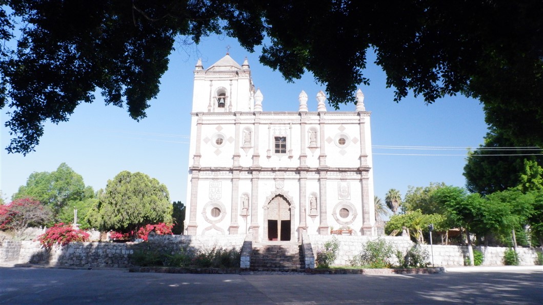
On the way to San Ignacio we passed a number of very old volcanos but on further examination we realized that some of the lava flows didn’t look that old in geologic time (we now believe they are from the 1700’s).  The overall scenery driving up the road to the town was lovely desert and mountains.  The town itself is GREEN!!! (OK we are from Washington, The Evergreen State and miss GREEN) as it is built in an area of springs and even has a couple of shallow lakes.  Entering town you drive through hundreds of closely spaced palm trees and then the town square is shaded by trees a couple of hundred feet tall. This is another town with a very old mission church (and once again I took the opportunity to sing in it so I could listen to the walls singing with me).  Our driver introduced us to an American woman who owns one of the original large haciendas in town.  She maintains the home almost like a museum and was eager to show us around and to answer many of our questions about the town.  We ate lunch and then started back down to the Sea about noon and felt like it had been a very good day and that our taxi fare was well spent.


Volcanoes along the route up the mountains
A fairly "recent" lava flow

Mission in San Ignacio

Inside the Mission in San Ignacio

Mission in San Ignacio

Town square in San Ignacio (first tall shade trees we have seen in Baja)


June 21, 2019

After Santa Rosalia we had hoped to enjoy some of the outstanding clear water diving we had heard about.  We have so far been pretty disappointed as the plankton blooms are pretty thick everywhere we stop.  We have passed through a number of areas of red algae (AKA “red tide”) so thick it made the water color range from brown to blood red. The only tradeoff is the evening and night phosphorescent shows are spectacular.   We moved up the north end of the Sea of Cortez at a fairly fast clip as the anchorages and marinas are getting fewer and farther between.  We did stop at a group of islands known as “Refugio” we could see why this little archipelago is the destination of a lot of campers and boaters as the scenery is spectacular and we are likely to go back that way on our trip south in August.  The other disappointment (besides the clouded water) was the amount of camping garbage on the beaches.  (We later heard from our friends on Saare Lil that they had met several “kid boats” in Refugio and that some of their fondest memories of the Sea of Cortez were formed while they were there.)

We rather suddenly found the water under our keel rapidly shallowing as we entered the realm of the Grand Canyon of the Colorado (or at least the sand washed south for zillions of years from its formation).  The Colorado river no longer reaches its natural terminus in the Sea of Cortez as every drop of water is pulled off to feed agriculture, provide drinking water and fill swimming pools as it heads south.  On the other hand the delta that remains is a clear testament to its history of power and Earth shaping through the ages.

Recognizing that we had sailed into an area of shifting sands we watched our charts and depth sounder readings very carefully.  When we enter the breakwater of San Felipe it looked like we wouldn’t have any problems but when we looked off our stern the next morning at low tide we realized that at least 50% of the area within the breakwater area is silted to the point of being dry land at the lowest tide.  Thankfully other mariners had added notes via a crowd sourcing program to our electronic charts which gave us a heads-up on how to approach the Marina Fonatur dock. 

After our last stop in Santa Rosalita we weren’t surprised at the low cost of staying at a Fonatur Marina but we were not happy with the condition of the docks.  In fact after a very long day at sea I recall feeling pretty let down when I realized we would be moored at a dock that was long past its’ prime in an industrial area a few miles from the main part of town.  What we eventually found was that Fonatur had repaired the upland parts of the marina and was actively working to rehabilitate the docks (they put several rebuilt sections back in the water before we left).    Security was very good with up to 3 Coast Guard boats at the dock (with at least one of them crewed at all times) and a full time security guard. Town was a fair bicycle ride away with the biggest challenge being that thorns hidden in the sand along the road kept puncturing our tires. 

On the way to San Felipe we had ordered a new sewing machine for the boat.  It is simple (kinda old fashioned) but built specifically for sail and canvas work.  The machine was to be sent to our friend’s business in San Diego for pick-up.  We also wanted to get some new watermaker membranes and convert our system to be able to use less expensive generic sizes.  A company in San Diego had the parts in stock and would not charge shipping if we picked them up at their assembly shop.  Finally we had a long list of marine parts we wanted to pick up and NOT have to try to get them into luggage from Seattle.  With all of this in mind we found a rental car (in excellent condition) and drove on very good roads to San Diego while Jarvis stayed at a doggy spa.  While we were in San Diego we visited with our friends the Grays and with boating friends as well.  We made excellent use of our time and picked up everything without problem except for the sewing machine which had been loaded onto the wrong delivery truck by FedEx.  The good news was that we knew it was in the San Diego area if we could track it down and eventually while we waited at the warehouse FedEx found the box and handed it over to us the same evening it was supposed to have been delivered.

Once back on the boat we were able to upgrade the watermaker and are very pleased that it is making about 40 -45 gallons per hour rather than the 25 gallons per hour we could get from our old membranes (we were especially pleased as we had been told to expect only about 30 gallons per hour until we had a chance to upgrade our high pressure pump).  The sewing machine challenged Clarice a bit as she got used to its idiosyncrasies but her first project with it was produced with about one tenth of the frustration that she had with her dressmaking machine and the stitches look much much better.


New membranes (blue on right) installed under bed

Clarice studies her new sewing machine

While eating dinner we met an expat couple who own a home in San Felipe.  They gave us a ride back to the boat and then visited and asked a lot of questions about our craft and living on it. During our stay in San Felipe they introduced us to dune buggy riding on the beach and in the arroyos and took us to see some of the sights in the area.  Joe used to sail on the Nimitz which for some time shaded our passage as we left our home port in Everett where it was docked. As such he was very familiar with boating systems and jumped at the offer to join us as we sailed across the Sea of Cortez to Puerto Peñasco (even choosing to sleep in the pilot house berth as it reminded him of his bunk on the aircraft carrier).


Baja Buggies

Buggie ride on the beach

New friends take us to a giant saguaro reserve

Speaking of the Colorado River Delta, like the Columbia River Delta back home it has created miles of sandy beaches.  Just outside of the breakwater was a beach that ran for miles and was very very wide at low tide (the tides at this end of the Sea of Cortez run up to 14 feet).  Jarvis was in little dog heaven for every morning and evening run on the beach.  There were many opportunities to increase his calcium intake sneaking fish bones off the beach when he thought we weren’t looking.  There were pelicans and other birds to chase and most of all there was lots and lots of room to run as fast as his little legs could go.


Jarvis was in doggy heaven on the sand beach in San Felipe

We are currently in Puerto Peñasco waiting for our planned haul-out next week.  Again we find ourselves at a Marina Fonatur and in a commercial harbor with many huge shrimp boats tied up together and a number of tourist boats ranging from “booze cruise” boats to “pirate ships” all of which seem to find it necessary to have VERY loud sound systems which start blasting music and other noise at about 6 pm while they load for the evening sunset cruises.  Other than that we have found its not too far of a walk or bike ride to the larger stores and to the sand beach that attracts hundreds of folks from Phoenix and Tucson.


Sandy Beach Puerto Penasco

We have run into a number of boats getting hauled in the same yard as us and in many cases they are part of the community in motion that is the reality of long distance cruisers.  We had friends who needed a ride to Phoenix where they could rent a car one-way to California and other friends who needed a ride to the airport in Phoenix to catch a flight back on their way to home in northern Alberta.  We found that we could rent a mini-bus for about $US 200 that would carry all 12 of us and had a roof rack for the baggage.  We drove the van north and enjoyed the scenery and picked up some new bicycle tires and puncture resistant tubes then spent the night in a nice motel before driving back the next day with a stop in Oregon Pipe Cactus National Monument. (Sadly after feeling very good about Jarvis staying in the kennel in San Felipe, I wasn't pleased with him being left in a cage in Peñasco - Clarice has been trying to convince me that Kennels are a good option at times but I will have to use a lot more care in choosing them before I will be willing to leave Jarvis with strangers again.)


Mini bus trip to Phoenix

DANGEROUS IN MEXICO???

About once every week or so we hear how dangerous it is in Mexico. Just today I had a person write a response to my TripAdvisor information about driving to Phoenix and back asking, “How safe is the travel from Phoenix to Puerto Peñasco currently…. Any issues to be aware of?”.  This was after a friend of Clarice’s had reported that her brother in Phoenix wouldn’t take her on a side trip to Rocky Point (the Gringo name for Puerto Peñasco ) because it was too dangerous.  Here is the response I wrote to the latest question, “We did not experience anything that concerned us driving between Puerto Peñasco and Phoenix and back. We have been advised by more than one expat living in Mexico to avoid driving at night. The only reason given was a concern for blowing sand on the coast road from Puerto Peñasco to Mexicali. We have heard more than one claim of "its dangerous there" from Phoenix residents - we don't know the source of the concern. We have been moored on our boat in the seedier part of town (its the only place to moor a boat) for a couple of weeks with walking and bicycles being our primary means of getting around and using common sense have been no more concerned than walking in the seedier parts of any USA city”.

On Facebook it is consistent that those of us who are here will write that using the same level of vigilance in the places we have visited that we do in USA cities has kept us safe so far.  We were most concerned about pilferage from our boat and dinghy in San Diego so we always locked the dinghy and bikes carefully.  On the other hand I have not seen my cell phone for several days and am convinced it was palmed while we were at a restaurant here in Puerto Peñasco .

Going back into the USA we were stopped twice at border patrol check points away from the border.  We were only asked if we had “appropriate ID” and sent on our way without actually showing any ID (the agent was caught a bit off guard when he asked if everyone was a US citizen and I replied no that we had Canadians in the vehicle).  This continues to feel “not right” to me after having lived near the border with Canada where such check points are rare to non-existent.  Perhaps it goes back to my youth and childhood when I heard over and over about the evil East Block countries that required citizens to carry identification papers at all times and that it was a sign that America was a great country because we had the freedom to travel without being stopped.  Here in Mexico we often are stopped at military check points and the officers all carry automatic weapons but this is not MY country and I don’t expect to have the same freedoms here as in the USA. 

Speaking of which a common question that comes up on the cruisers’ forums is about carrying firearms on boats.  The common answer is it is a pretty stupid thing to do unless you like visiting foreign jails or having your boat confiscated (answer to the next question: we carry bear spray in case of a low level piracy attack – for a high level attack they can have the boat and we will go overboard in the life-raft).  Clarice ran into that worst case “ugly American” response on one forum when someone wrote in, “but it’s my constitutional right to have my guns”.  All we can say is that if you don’t understand that the US constitution only applies in the USA then please go back and take 6th grade civics and for the sake of the rest of humanity get rid of your guns as you are too stupid to own them responsibly!

So to end this section of random thoughts, I have to ask what makes us feel safe or not safe.  Someone wrote that the Mexican police presence with them all carrying automatic weapons made them not feel safe.  Curiously I think that many of the police on the corners in Cabo are there for show so that the tourists worried about drug cartels will feel protected. On the flip side I have long had a bad taste in my mouth from visiting Phoenix in the 1970’s when I was a high school student with pretty long hair.  I was riding my bike down the highway and was randomly pulled over by a police officer in a car (not a motorcycle) who got out of the car with a riot helmet on.  I remember being struck by the barrier the officer had created between me and him just because he felt a need to look “tough”.  Every since that incident I have been a big fan of “officer friendly” type programs and have gone out of my way to say hi to cops on the beat (especially those on foot or bicycle) in appreciation of how little it takes to make a wall between us. In another instance I recall a student MD visiting our clinic in Belize complaining that there wasn’t a phone in the dorm and what would they do if there was an emergency.  What she hadn’t taken the time to consider was the reality that the police might ask for her to drive and pick them up as they often ran out of fuel part way through the month, and had they responded they might have not been impressed at her complaint about a robber who happened to be the cop’s brother-in-law.  What does this all come down to?  In the end “being safe” is a very culturally based concept and varies greatly from place to place and person to person.  If you are going to travel then you are going to have to get used to being responsible for your own safety and recognizing that every choice you make from what you wear to how your body language expresses confidence, to where you choose to travel and at what times defines how safe you are likely to be.

So is it safe in Mexico? Yes and no.  Is it safe in Seattle? Yes and no.

Parting thoughts and photos before I publish this post:


  • In the May post I wrote about trying to keep my nursing brain functioning.  The current plan is that in September and October Clarice will stay in a marina in Mexico where we have a number of friends and work on boat projects (and hopefully have a long-time friend of hers visit) while I head off to Hillside Clinic in Punta Gorda Belize for a month.  This is the clinic where Clarice and I spent the year of 2004 in the very southern tip of Belize Central America.  A funny aside is that one of my motivations for choosing the clinic was that my Belizian nursing license specifically says, “without limit of time” so I assumed it was still valid and I wouldn’t have to go through the hassle of getting license reciprocity in another state or country.  The clinic director had never seen such a thing as the Belizian licenses now are time limited but on checking with the national board it was confirmed that my license is still active. (I have always joked that I go through a sex change when I enter Belize as well as the licenses of the era only had female pronouns even though I know of at least one other male who was a nurse in Belize at the time.) Hillside Clinic Belize


  • Boat Projects: Clarice is focused on getting the boat clean and ready for our haul out. I completed another room of my floor sanding project.
Sanding the floor
Floor after varnish (it was the sun bleached color of the vertical wood)


  • We have received word that the school we have been supporting is Esperanza near La Paz is near ready for students.


Wednesday, May 8, 2019

Missions of Baja


4-30-19

We seem to have passed a transition zone in the Sea of Cortez where the scenery changes as well as the wildlife.  One way I monitor if it’s time to start typing a new blog entry is to watch the number of photographs collecting on my desktop.  When the number starts to climb rapidly it means we are seeing new sites that we are eager to keep a memory of and thus there are more adventures and sights to share.

Some time back I had downloaded several audiobooks thinking that I would use them to help me stay awake on night crossings but since we have not made any night crossings the books have stayed on the electronic bookshelf.  One of the books is the Log of the Sea of Cortez by John Steinbeck and co-authored (per Steinbeck according to the introductory information) by biologist Ed Ricketts.  The book was taken off of the shelf a few weeks back when we got an email from a friend we had gone to church with in Sitka Alaska reminding us that Ed Ricketts family were long time members of the church and had worked to keep his legacy alive.  Their boat was the Western Flyer built in Tacoma and seen by Clarice and I both as we past it moored in the Swinomish Channel (before it sank) and later while it was in the beginning process of being restored at the same shipyard where we had Salish Aire hauled out back in August https://www.ptleader.com/stories/work-ramps-up-on-western-flyer,58805?. The timing for beginning to listen to the book could not have been better as Steinbeck and Ricketts stayed in many of the same anchorages that we had and we were able to mentally compare what he described from the WWII era with today.  The only place that seems to have changed completely is the area at the tip of the peninsula where Cabo San Lucas has been planted (and grown into a rather unruly mess in our perception).  The coves and other sites he tells about are still there today just as he described them.  Even his description of entering La Paz has not changed nearly as much as one would expect with the sand bars just as he described them and the range (navigation) lights still in the same locations.  I am now at the point in the book where he describes the changes in what they are observing and we are seeing pretty much the same things as we move northward.

In Steinbeck’s book I have just finished the chapter on Puerto Escondido which seems appropriate as the last blog note ended with our entry into the harbor but with little description of it.  Steinbeck describes Puerto Escondido, the Hidden Harbor, as “a place of magic” and comments on how perfect of a natural harbor it is [Chapter 16].  It is such a perfect harbor that we had questioned if perhaps two areas between hills surrounding the harbor had been filled in as man-made breakwaters but since Steinbeck also mentions them as present when he visited the bay they are clearly natural.  To enter Puerto Escondido the navigator must first find the narrow entrance hidden among the hills. Thanks to unusually accurate charts and GPS this was not a terribly difficult challenge in 2019. You then pilot the boat nearer the reportedly deeper south side of the narrow entrance channel (now dredged but not deep enough in Steinbeck’s time so that his crew chose to anchor in a cove next to the entrance now known as the “waiting room” as larger boats sometimes anchor there while waiting for a high tide).  Once inside of the channel the harbor is nearly a perfect pool and quite deep.  The water was not clear for us as algae tends to bloom in enclosed harbors and when we lost our boat hook in 40 ft of  water it was lost for good since I could only see about 2 ft when I dove to the bottom to look for it.
 
Puerto Escondido

Puerto Escondido keeps trying to make itself into a very high-end marina and housing development.  Initially the project was started by the Mexican government but it wasn’t well maintained even though they had built some well-designed buildings and some of the nicest boulevards we have seen in all of Baja.   A couple of years ago it was taken over by a private concern and they have upgraded the docks and built a 6000 Sq ft hacienda  between one of the dug canals (with private docks) and the lovely boulevards.  On one hand I wish them the best with their endeavor but on the other I would really hate to see this incredible natural setting become another Cabo.

Puerto Escondido is about 20 minutes south of the town of Loreto by car on a highway in very good condition.  We rented a car and used Puerto Escondido as a base for several days of exploration and provisioning.   Loreto is the oldest non-native settlement in Baja with the oldest mission church.  Steinbeck visited the same church and commented about it being in ruins with the roof fallen in and only the bell tower and one small chapel standing.  The church has obviously been rebuilt since then and is now shared as a museum.  We had looked forward to Easter Sunday in this culture that we considered to be “very Catholic”.  We scoped out the mission on Saturday afternoon and understood  that  that church was closed until 7 PM.  We assumed there would also be a Sunday service and after talking with several people were convinced it would be at 7 AM.  We arrived at 7 AM Easter Sunday and the building was locked.  At 7:30 the bells rang and the building was opened to the public but no formal service.  We came to believe that the service the evening before had been THE Easter service.  Since it was still early and we had been told that the mission church at San Javier high in the Gigantic mountains was well worth the drive we decided to head there.  Steinbeck describes going up a mountain trail out of Loreto to go mountain sheep hunting.  While they never did see any sheep they loved the trip and spent a night at a cascading stream.  I strongly suspect that the trail he followed was to the San Javier Mission and that the road now follows much the same route.  I even believe that a spot where I commented to Clarice about it would be amazing to see in the spring with water falling over the cliff may well be the same spot where Steinbeck’s party camped.


Mission at Loreto


In any case we drove up and up on a very windy mountain road that was thankfully in excellent condition.  While the scenery along the road was spectacular we kept wondering why the crazy Jesuit priest had gone way the heck up in these mountains to establish a mission.  Once we arrived we understood as there was water.  The mission is in a valley where even in late May there was running water.  The mission was really quite lovely and it has aged well since being completed in 1758 on the site where the mission was founded in 1699.  Many of the original irrigation works made for the mission gardens are still intact.  The oldest olive tree in North America is also on the grounds having been started along with a vineyard (gotta have that wine!) by the priests.  We were able to establish that the Easter service was scheduled to begin at 1 PM  so we walked around town, napped in the car and in general got very warm in the heat.  Finally at noon we agreed that since scheduled at 1 PM in Mexico likely meant a 1:30 start and since we had a dog in his crate on the boat, and a 1 hour drive back down the mountain, we would forgo Easter services this year.  We were able to contact some friends once we were back in cellphone range of Loreto and that led to an enjoyable afternoon.


Back in the Episcopal Church we attended in Snohomish Barbara and Bill Bates and their children were major pillars of the community and the church.  While I only knew them from church, Clarice being native to Snohomish, had gone to school with one of the Bates’ daughters.  Another friend from the church follows us on Facebook and noted that one of the Bates sons and his wife were at their second home in Loreto so she put us in touch.  While neither of us had met Stuart or his wife (also a Barbara) we fell in easily with them as they clearly had the Bates family trait of being “good people”.  They came out and visited us in the marina and on the boat for Easter afternoon and offered to take us to see their home and the town the following week.   The day that we visited them at their home we were impressed at the housing development where they live and even went so far as having a realtor show us around in case either of our children wanted to go in on a place in Mexico (they didn’t).  


A little about the changes in what we are seeing in the Sea.  We are diving more as the water is starting to warm up a bit and get clearer.  We have been told that the northern Sea is a divers’ paradise especially when the water clears in the summer (the exact opposite of what we are used to from Salish Sea diving).   The numbers and variety of sea critters are clearly increasing although the water is still fairly cloudy at depth.  In the shallows where we snorkel the water is often crystal clear with huge varieties of animals. Steinbeck mentioned swimming white crabs about 2 inches long that I had never seen until a couple of nights ago.  Most nights we hear many splashing noises as fish gather around the boat.  The light from our windows and deck lights attracts millions of krill and other tiny tiny life to the water next to the boat which in turn attracts schools of small fish (and the other night probably 100ish little swimming crabs) which in turn attracts schools of larger fish including one evening a 4 foot green eel swimming near the boat and another night a sea snake or small eel.   We delighted in seeing 6 inch flying fish with their gossamer “wings” swimming just under the surface and periodically “flying” across the surface.  When we turn a strong flashlight downward we have a virtual aquarium right next to the boat.

Today as we motored north to the anchorage at San Juanico we were delighted to see a pod of 100 or more dolphins heading towards us.  I put the 400 mm lens on the camera as they were expected to pass at least 200 yards to our starboard side.  Just as I was finishing setting up the lens the dolphins decided we looked interesting and did a 90 degree turn to visit within a few feet of our hull.  I tried to get a video with entirely the wrong lens but at least a couple of frames could be pulled out.  In any case it is always very exciting when the dolphins visit as they seem to be as aware of us as we are of them and they seem to exude pure joy as they play in our bow wake and leap out of the water.   When we were near the entrance to the bay (with three sets of charts which all showed rocks and islands in entirely different locations) we saw areas of brown in the blue water.  We immediately slowed the boat and I went to the bow to try to ascertain if there was a reef near the surface that threatened to ground us.  What we finally realized was that we were seeing an orange/brown algae bloom.  The water here in the bay is currently thick with green and orange algae after friends told us it was crystal clear this morning. 


Friends on S/V (Sailing Vessel) Korvessa had mentioned that the night before the bay was alive with phosphorescence after dark so we made a point of checking the water after watching a video and wondering if the algae bloom might be a portend to a big light show.  To say the bay was alive would be a huge understatement.  We have paid to go on trips to so called phosphorescent bays and they were only a 10th as bright as we saw here.  The millions of krill each caused a minute sparkle in the water as they moved about like twinkling stars.  Below them as deep as maybe 8 or 10 feet we could see the clear images of fish swimming past.  In the distance fish jumping would appear as a flash in the dark.  Overhead it was a moonless night with zillions of stars so bright that their reflections completed with the phosphorescent images in the water.  THEN came the final act!  About 1:30 AM Jarvis woke me with a gentle "woof, woof".  Not his usual "I gotta get a drink and pee" bark but enough to waken me in any case.  While he stayed on his bed I went up on deck to check things out and was rewarded with a scene straight out of a Disney animation movie.  A parading school of rays about 20 feet wide(each fish about 2 feet wide)  was about 10 feet off our bow.  I could not see the front of the line in the distance but could only see the rear guard coming so when Clarice didn't respond to my call I stood watching alone.  Under the Milky Way the rays were each clearly lit with the blue-green light as they flew through the water slowly flapping their wings with a few breaking the surface to make even a brighter light. My only wish was that I had the skill of Jeremy Gregory or Elise Lebeau to put brush to paper to record the scene as our earlier attempts to photograph the lights proved our cameras were not up to the task.  Truly this will be one of the most magical nights we have ever experienced in our memories.

Using our most sensitive camera and with Clarice swishing a kayak paddle the best we could do was give an idea of the glowing color of the water


I have always wondered how the great baleen whales and whale sharks could live on the tiny shrimp known as krill.  How could they possibly gather enough of the tiny creatures to make a meal for such huge animals?  We now understand krill better after seeing them swimming en-mass under our flashlights at night and seeing how many cling to our wetsuits after we clean the bottom of the boat.  The primary stuff that clings to our main hull here is a thin layer of some kind of biological slime which comes off easily in sheets using 12 inch wide stainless Home Depot plaster knives.  Apparently the krill live in or on the bio-slime and when it is stripped of swim to the nearest dark colored refuge which happens to be our wet suits.  The other day a friend mentioned that he had been paying to have his keel cleaned only to find that the diver was only cleaning down as far as he could see with a quick inspection.  On closer inspection he found that his wing keel was not being touched especially on the lower surface. He was trying to catch up on the cleaning by free-diving (breath-hold diving) and using a 3 inch wide putty knife.  I offered to take a look at the keel after we had been on a recreational dive and I had a lot of air left in my tank.  When I got to the bottom of the keel I found hard growth as thick as 2 inches and had to whack it as hard as I could with my plaster knife.  I was thinking I was glad that no representative was in the area from the save-a-reef association as they might immediately serve me with a stop work order for destroying a new reef in formation.  On the other hand I thought about suggesting that Mark try to make some income by offering his boat as a model for the next Disney movie, perhaps the next Pirates of the Caribbean filming could use it as a ship that floated around the sea after having been abandoned and was being slowly reclaimed by Poseidon.  In reality the growth slows a boat noticeably and costs a lot of fuel when underway using the motor so it is best to keep the boat’s bottom clean and so I whacked and scraped and eventually was able to clean the whole hull before my air gauge showed I was below my safety reserve and needed to surface.  On surfacing I found that every bit of my suit and gear were covered as deep as 3/16 of an inch with krill.  I rubbed off as many as I could in the water and then had Clarice spray me with the forceful stream of our seawater rinse system and finally I stripped and she rinsed my gear again in fresh water while I took a shower and got most of them out of my hair and off of my body (I think the final one was cleaned out of my ear a day later).  In summary we now viscerally understand that there is enough krill in the ocean to feed the great creatures that depend on them.

Speaking of charting challenges, we were given a free set of electronic charts on the agreement that we would help show the variations between those charts and another set we had paid for.  I will include a sample of one variation that we sent to the chart company.  All we can say is that we were certainly spoiled in British Columbia and Alaska where rocks are charted within a couple yards of their actual positions.  Here we give ourselves a +- of about 1/8 mile and recognize that many rocks are not charted at all.

Map data program "A"

Map data program "B"
Chart from guidebook


One of our challenges is planning far enough ahead to have a clue of what we are going to do and to keep our insurance carrier appraised of where we will be within the next policy period but at the same time not over planning to the point that we aren’t comfortable changing course if we simply aren’t having fun anymore.  Currently our plan is to continue moving north in the Sea of Cortez to its very northern reaches where we will have the boat lifted out of the water so that we can enjoy some “vacation” time for the month of July.  After that we will move south as the hurricane weather allows and eventually cross through the Panama Canal to the Atlantic Ocean.  So the question comes up what is it we are looking for – what is “fun” – what is “adventure” and to me I keep asking “what is my purpose”.  This is not the first time we have asked these questions nor will it be the last.  In any case I often find if I write down my random thoughts they become more ordered and start to make sense.

For those who missed the detail along the way, Clarice and I are both retired Registered Nurses (I am never sure if I should put “RN” for fear someone will associate it with captaining a long distance pleasure boat and assume it means “Retired Navy” which is absolutely not the case).  We are both licensed in the State of Washington (and also in the Country of Belize but that is another story) under the category of “Active Retired” which translates to we can still work as RN’s but aren’t required to put in as many “practice hours” or take as much continuing education nor pay as high a license fee in exchange for the limitation that we can only work a limited number of hours.  Washington was clever in creating this category in that it keeps nurses who might have stepped completely away from nursing available to fill-in when there are shortages (which happens more often than not in our profession) and it keeps we old mentor types around to pass on the skills that are honed only with time.  We are both coming up on dates when we will need to either let our licenses lapse or be ready to demonstrate that we practiced our craft and continued to study the art.  Getting the continuing education is not the issue as we can always get credit over the internet if not in other ways but we also need to do jobs that require an RN after our names if we are to meet the practice hours  requirement and we are not sure at this moment how we will do that.  I will speak for myself and say it would be hard to set what has become a very significant part of my self-image aside on one hand and yet I am very burned out on the other.

Back when I became an RN in 1983 there were very few men in the profession.  It was assumed that you were ex-military or gay if you were a man who was a nurse and I am neither so I felt even further afield.  In many ways it was fun to be “special” on the other hand I quickly learned that anyone who is a leader (by plan or happenstance) is watched very closely.  In my case I was also challenging tradition and traditions don’t like to be challenged.  Early in my career I chose to be a labor and delivery nurse as we were having children at home and I was excited to be a part of this time in my patients’ lives.  Not a lot of folks know that my master’s degree is in perinatal (moms, dads, and babies) nursing.  I am among a very small group of nurses who specialized in caring for fathers during childbearing.  The problem with this is that care of mothers is traditionally women’s work and some of my co-workers went out of their ways to protect that tradition which made my life difficult at times.   I recall my first week working at a major hospital where I was the only male nurse in the building when they needed a model for some public relations photos.   I loved the work I did, I loved the hundreds of patients I cared for, and I loved the hundreds of students I mentored as a professor of nursing and as their supervising nurse in the hospital so why did I feel so unburdened when I retired almost 2 years ago?  About that time either in an interview about her book or in her book, I can’t really remember where she made the comment, Michelle Obama talked about her last helicopter ride as First Lady.  She cried the whole ride in sheer relief.  In looking back she realized that as the first Black First Lady and the wife of the first Black American President every word she said, every expression on her face, every button on her clothing was scrutinized and she had to always be the best she could be because she was setting the standard and a whole lot of people wanted to see her fail.  When I read (or heard) that comment I realized that I felt somewhat the same as I had spent from 1983 to 2017 being scrutinized and trying to always do my best knowing that I was breaking barriers.  It was exhausting but with the pride I feel and the knowledge I carry and the love I have for caring for patients and teaching new nurses I’m not sure I’m ready to step aside.  So keep abreast of the blog and we’ll see what happens together and Clarice and I are still making this up as we go along.   The good news is that when I talk to the many young men now choosing to be RN’s that they assure me they have not experienced those same barriers so in many ways I believe I left a solid legacy in that sense and made the profession better by opening it up to a whole lot of folks who love what they do and are good at it but might have never considered becoming nurses except those of us who took the early lead.

Now back to moments that make our travels remarkable and can never, ever be recreated on film or in a book.  These are the moments that happen at times when it just seems like we are just “bobbing around in the ocean”.  Jumping back to Alaska I think of the bay in Kenai Fjords where we were surrounded by at least 6 glaciers and could hear the hanging glaciers calving into ice-falls and all-the-while a whale swam around and kept us company.   In Alaska I think of sitting in a remote hot spring,  watching a couple of bears forage on the beach while the sun was taking forever to set.  Coming down the coast the first time we were accompanied by porpoises and then later shutting off all of the lights on the boat on my night watch and watching the phosphorescence from our wake and seeing stars from horizon to horizon.  Seeing the rays swim past the other night looking like a scene from Finding Nemo combined with Avatar is a moment that is almost beyond my own belief and I was there!  Finally we visited a mission yesterday that was hundreds of years old.  We and friends and our taxi driver were the only ones in the chapel with its four foot thick ancient stone walls.  I took the opportunity to sing with my full base voice and the walls of the chapel came alive and sang with me, another experience I could only have by being there at that moment in time.  So we will continue to bob around and be open to such wonders when they happen and hold those moments in our hearts and do the best we can to share them with our readers.

Mission Santa Rosalia with our friends from S/V Korvessa

The final question about our purpose is still out there.  When Clarice and I started this quest we were very clear with each other that we didn’t want to consider having cocktails on the beach (the cruisers equivalent of golfing every day) to be our goal in life.  We wanted to feel that we have given back to the communities and peoples we have come into contact with.  Helping with the school fund raising was a part of that (although I’d much rather mix concrete and help with construction than raise funds but that would be taking from the local laborers rather than giving).  We  arranged for a parents’ night out for cruising families with children and we have gotten to be known as the place to turn if your boat breaks down or you need a hand.  These things make us feel valued but I’m not sure they rise to the level of “purpose” yet.  On the other hand, God has always challenged my limited patience while he prepares me for His work and this may just be another one of those times. (Maybe he thinks I should be able to do more than order my meal in Spanish first – gotten keep working on my lessons!)  Again, keep reading our blog and time will tell.

5-7-19

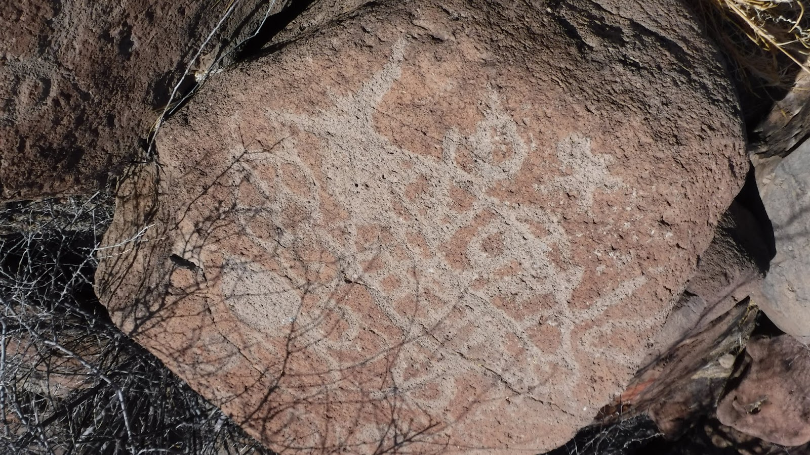
We still aren’t in an area with general internet access so I will keep writing on the draft of this posting even though it is getting a bit long.  Yesterday we helped Korvessa take on fuel from our tanks as they were getting concerned since they have used more than planned between more need for generator use and less time under sail than they had expected.  In the evening we moved a short distance to Bahia Burro with the plan of leaving early for a hike up Bell Mountain.  This morning we left at 7:30 up what we thought was the correct trail (it wasn’t but eventually we found the cairns that let us the right direction).  The lower half of the trail pretty much involved scrambling over rocks up a gully.  Later we intersected what appeared to have been a very old road of some kind which left me wondering if it was an original mission trail or perhaps a mine access route.  The final fifth of the route was short slippery switchbacks to the base of a rock pile that was Bell Mountain so named as some (but not all) of the rocks that fall from it ring like bells when struck.  We still cannot find any obvious difference in appearance between those that ring and those that don’t but tapping them with the hardened tips of our hiking poles quickly revealed the ringers.  In any case the sound was very distinct and very bell like on some of them.  It did make the hike down the mountain go more quickly as we tapped rocks along the way looking for the ones with tone.  It was especially interesting that the ones that rang only seemed to have come from the single small peak.  The trail was also reported to have petroglyphs along it so we watched for them the whole way up and the whole way back only to discover their location as we exited the trail.  They were all within 30 feet of the highway but at least we did get the satisfaction of finding them.  Jarvis  waited this hike out  and was glad to see us when we returned to the boat.

Petroglyphs at the base of Bell Mountain

Petroglyphs at the base of Bell Mountain

The "bell" rocks seem to all come from the little peak in the center of the photo


Video of the bells of Bell Mountain


Finally just some random photos since the last blog entry:

Paddle boarder with whale shark

Moonlit night


Flock of "little diving birds" - a flock will suddenly disappear below the surface and then reappear a bit further on

Clarice hiking

Jarvis taking a break in his hiking boots
Coronado Island volcano


Salish Aire from the top of Coronado Island volcano

 These creatures cover themselves with other sea life we assume for camouflage 

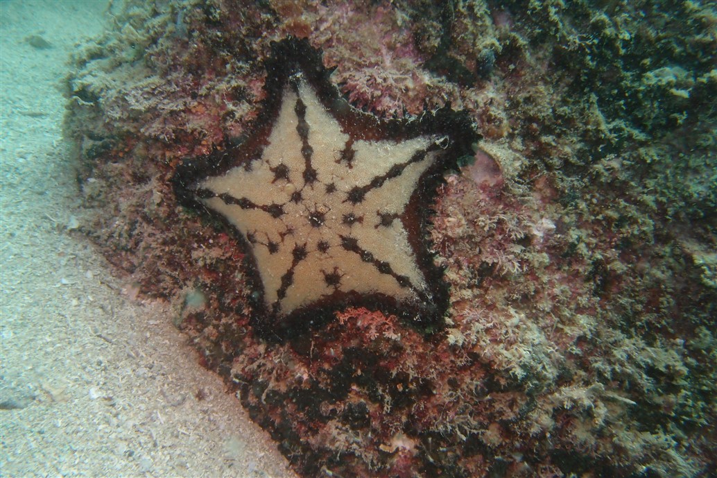
One of many kinds of sea stars we see while diving

A bulls-eye ray we saw while diving