There are those that say you should never start a journey of
any importance of Friday – much less Friday the 13th but for better
or worse that’s what we did. April 13,
2018 we slipped our moorings in Sitka and headed to Olga Strait. Our friend Elizabeth stopped by for final
hugs on her way to work and our radio pals wished us the best as we reached the
limits of the VHF repeater and then the first sight we saw of Sitka back in
September when we arrived became the last sight before heading behind the first
of many islands. I made a comment to
someone about the “three months” we had spent in Sitka and Clarice quickly
corrected that it had been nearer to eight.
Perhaps that says everything about our stay – we had held some
trepidation about how long the winter would be in a small Alaskan town and
instead the time passed faster than we knew.
So with the sky now being light before we get up at 6 AM and remaining
light when we go to bed at 9:30 PM we are eager to continue our adventure.
We had been told that Deep Bay, just past Sturgis Narrows
might have Dungeness Crabs in it so after passing through the narrows during the
slack tide we turned in for our first night at anchor. We did find a couple of crabs in our trap
after a long walk with Jarvis on the river delta at the head of the bay on low
tide. It was a lovely day with lots of
sun but the snow still lingered on the beaches.
 |
| Back out on Chatham Strait |
 |
| One of our few orca sightings |
 |
Baranof Island |
We had never taken time to visit the Native Village of
Angoon.
As we headed across Chatham
Strait we were able to reach a local sail boat on the VHF radio who explained
that entering the east side of the peninsula that Angoon sits on to reach the
village docks was not advised in a displacement boat on an ebb tide as the
currents were quite swift and rocks very plentiful. After some discussion we
decided to anchor next to the new Alaska State Ferry Dock on the Chatham Strait
side of the peninsula behind some small protective islands.
We launched the dingy and carried our bikes
to dingy docks conveniently co-located with the ferry landing.
We then rode our bicycles the 2.5 miles to
town.
Many of the buildings on the way
to town were well kept and fairly new but a fair number of the buildings in the
village itself were boarded up and/or in poor shape.
We walked to the historic Russian Orthodox
Church that is now boarded up and starting the process of returning to the
soil.
 |
| Chatham Strait side of the Village of Angoon |
 |
| Looking from the Russian Orthodox Church back towards the bay side (east side) of Angoon |
 |
| Looking over the Village of Angoon towards the Russian Orthodox Church. Grave crosses on the hillside and in the forest beyond the church. |
One day in Sitka a new skiff arrived at our dock and we
invited the young couple who owned it over for dinner. They explained that they were permanent staff
at a fish hatchery on the eastern side of Baranof Island and had come to town
for one of their few outings to the “big city”. Their names were Emily and Jon
– more about them and young folk like them later. We decided to take them up on their
invitation to visit the hatchery for our next stop. They showed us around the operation and
explained that it is the largest hatcher in North America producing several million salmon a season. Many
of the salmon they release in the bay where they are located but even more are
taken by boat or plane to other bodies of fresh water and released. Some of the lakes where they are released
have waterfall outlets that the salmon can’t return back up so they make a
one-way trip as smolts down the falls (or in one case, down a water slide) and
then go to sea to grow for four or five years.
When they return the plan is that natural predators and human fisherfolk
will eventually catch them all. The hatchery is owned by a private
not-for-profit company that makes its income by charging the fisherfolk for the
hatchery grown fish they catch. To
identify the fish they “bar-code” their otoliths (ear bones) by varying the
temperature of the water they are raised in soon after they hatch. Each hatchery has a specific code that can be
interpreted under a microscope and then the number of fish interpolated and the
hatcheries paid accordingly. Apparently
the fisherfolk feel they get a good deal and plenty of stock in easy to catch
locations and we the consumers have plenty of wild raised salmon to eat. After a dinner of fresh caught BBQ shrimp
tacos we slept soundly at the hatcher dock and then moved on the next day.
 |
| On the Hidden Falls fish hatchery dock |
 |
| Entry to Hidden Falls hatchery |
 |
| Emily and Jon's house at the hatchery |
 |
| Hidden Falls hatchery |
Our next plan was to spend enough time at Baranof Hot
Springs to be able to really enjoy the springs and to explore the area a
bit.
On arrival we walked up to the lake
that supplies the waterfall which still had a layer of ice over all except the
exit stream.
It was really rather
beautiful with the surrounding mountains.
We laughed when we learned that row boats and canoes grow on trees (or
so it appeared the way the locals stored their craft for the winter).
On our way back down the hill Norman took
time to soak in the natural hot springs pools next to the hot spring source of
the village’s warm waters.
 |
| Apparently boats grow on trees in Alaska (or their owners only want to carry them up to the lake one time and choose to store them this way over the winter) |
 |
| Baranof Lake above the hot springs (still mostly ice covered) |
 |
| Clarice enjoying the sun at Baranof Lake |
 |
| Family "selfie" at Baranof Lake |
 |
| Natural hot spring pool next to the river outlet from Baranof Lake |
We met a
young couple with their one and three year old children that served as this
winter’s caretakers for the homeowners association.
They explained that after sailing for years
across the open seas they didn’t find staying at a cove with only a very rare
visitor to be too much of a challenge.
For lunch and dinner we were invited by the caretakers of the fishing
lodge next door.
 |
| The Baranof Hot Springs Potluck breaks up for the night |
During the day we
launched the kayaks and rode the rising tide into a tidal lagoon.
We decided to leave before the tide changed
and learned a lot about paddling against a strong current and using back eddies
for rests until we eventually paddled clear of the entrance slot.
 |
| Jarvis navigates as we head through the channel into the tidal lagoon |
 |
| Clarice rides the incoming current into the lagoon |
 |
| Inside of the tidal lagoon off Warm Springs Bay (Baranof Hot Springs) |
 |
| Waiting for the current to let up so we can exit the lagoon |
Before the
evening was out a couple that run deliveries to these scattered outposts with
their retired army landing craft pulled in to get out of the weather. Speaking
of the weather, after it being sunny and warm for two days we planned to leave
the next morning.
We woke to rain and
decided caution would suggest listening to the weather forecast.
It seems a nasty cold front is bringing gales
for two days and so we decided to sit tight.
When two much larger commercial craft joined us we knew we had made the
best choice.
April 20, 2018
Today the weather turned for the better and Lituya left
followed shortly by us with both boats headed to Petersburg about 9 – 10 hours
away. Lituya is owned and operated by Hillary and Chase who join a number of
young couples we have seen who have joined together not only as a couple but
also as business partners.
Emily and Jon
at the Hidden Falls Hatchery are another such couple.
When we were in Sitka our friends Jacquie and
Zack are another such couple who recently purchased a fishing boat, the
FV Axel, as their family business.
Hillary and Emily especially stand out as
they are both very petite (and Hillary even has the blond hair and blue
eyes to carry out the "full ultra-petite look") but after watching Hillary handle the lines on their landing
craft I would not suggest asking her to arm wrestle.
The same goes for Emily whose husband proudly
tells the story of her bagging her first mountain goat after climbing a
trailess mountain requiring crampons and ice-axe and then carrying the 125
pounds of meat down the mountain on her 95 pound body.
The characteristic that all of these young
men and women share that stands out to us is their self-confidence – these are
“strong women” (and men).
Clarice
commented that she has noticed that they are comfortable joining in
conversation with folks of any age group.
I once commented that seeing kids from high school on up that appear
comfortable with themselves without feeling the need to dress up or make sure
their makeup was on just right before leaving the house has been
refreshing.
These “kids” are the future
of Alaska and they are taking it seriously as demonstrated by Jacquie and
Zach’s involvement in the local seafood cooperative and Jacquie’s getting involved in reaching out to get training for the next
generation of fisherfolk (we simply saw too many women involved in the trade to
think “fishermen” is the correct term anymore).
 |
| Hillary and Chase in front of their landing craft Lituya |
April 26, 2018
After a fair weather run to Petersburg we watched heavy rain
for 3 days. We didn’t exactly sit as there were indoor places to visit and
stores to check out but it was not what we had hoped for as Petersburg is a
lovely little Scandinavian village at the north end of Wrangell Narrows. We had made a special effort to go there as
we had nice memories of the place from visiting for the Nordhavn rally in 2015
and wanted to get a chance to check out favorite sites and to see new
ones. We did visit the local Episcopal
Church on Sunday morning with its tiny congregation. We immediately recognized
Heidi from a discussion with her the day before about some luggage we need to
get repaired but I kept feeling that I should know her from something
else. We finally put it together that
she was one of the primary hosts for all-things-Norwegian during the Nordhavn
rally (providing meals, leading dances and dancers, etc). It was good to get a chance to enjoy her and
the other folks company.
Finally the weather broke on Wednesday and we planned to
leave fairly early but we still had not had a chance to check out the south end
of Mitkof Island. I was walking Jarvis
when Chase from Lituya drove by and stopped to say hi. Later in the morning he took Clarice and I
for the tour we had been hoping for. Mitkof Island was well worth the effort
and along the road we saw our first black bear (rather than Alaskan Brown Bears
that are common on Baranof Island), a cow moose walking in the road and a
couple of dear. (Since leaving Sitka we
have seen our first pod of Orca, Dahl Porpoises playing in our bow wake, geese
flying north in huge Vs, and mountain goat since our trip began.)
We are currently heading out of Tracy Arm. Tracy Arm is a
bit of a gem well known to folks in SE Alaska but not well known elsewhere as
it is not a national park or monument.
It IS an incredible fiord that has two tidewater glaciers at the far
end.
When we visited in 2000 we followed
the advice of locals and took time to go into Tracy Arm on our way to Juneau
and have always considered the side trip to be one of the highlights of the
trip.
We were a bit concerned as there
were low clouds and rain when we pulled anchor this morning but the clouds rose
and rain stopped and the “WOW” factor began as we travelled up the fiord.
The chart shows water over 1000 ft deep only
yards away from 1000 ft tall cliffs and higher mountain tops on both sides of a
channel so narrow that when we were here in 2000 a cruise ship had to radio and
ask us to take the inside of one curve as he could barely make the corner.
This is where we saw two tiny dots on the
cliffs that turned out to be a pair of mountain goats and twice we watched dramatic
ice waterfalls come down the cliffs.
The
South Sawyer Glacier was pretty impressive but we were limited in how close we
could get as the channel in front of it had a solid layer of ice for some
distance out.
Our memory was that the
North Sawyer Glacier could be seen from the main channel when visited 17 years
ago but this time all we could see was a steep walled curving channel.
On our way back out we turned into the
channel and passed over a bar that was located where we remember the glaciers
snout to be in 2000.
We continued on for
another 1.5 miles, past the point where the glacier was charted to end on our
2015 charts and came to the snout; it was well worth the trip.
The sun was trying to break through and the
ice bergs were spread out enough that we could get as close as we wanted to the
intense blue ice.
The canyon walls
themselves were quite dramatic as well having only recently been exposed after
being scraped by the ice. In the end we agreed that Tracy Arm is in many ways
much more dramatic than the much more storied Glacier Bay National Park.
 |
| Tracy Arm North Sawyer Glacier closeup |
 |
| Tracy Arm North Sawyer Glacier |
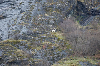 |
| Tracy Arm mountain goats |
May 2, 2018
We visited Juneau for several days (a bit longer than we had
planned due to foul weather and looking for a lost piece of mail). We rented a
care with 213000 miles on it (that sounded like a logging truck until it warmed
up) and made runs to several stores for provisions and other supplies. On April 29th we drove to the
south end of town (AKA: Cruiseshipville) and noted that it was still pretty
vacant except for a few establishments setting up their wares and doing
employee training. On April 30th
we visited again when the first cruise passengers of the year were
disembarking. We can’t understand how
every cruise port can support several blocks of jewelry stores but they
do. I walked into several stores and
looked at watches and was immediately accosted by at least three salivating
salespeople per store eager to practice their newly memorized scripts about how
wonderful their brand of watch was. It
was fun to be in a “big city” for a few days but even better to move on.
Today our plan was to return to an anchorage that holds very
fond memories from our trip in 2000. We first had to find the entrance and
since GPS coordinates were just finding their way into guide books and weren’t
always accurate it was a bit of a challenge.
We remember going through a “J” shaped narrow channel against a fairly
strong current to get into a totally enclosed bay. There were hundreds of salmon jumping all
around us. Since we couldn’t figure out
how to catch any a commercial fishing boat tossed us two fish out of sympathy.
Clarice had made a note on our chart, based on her guide book research, to only
enter on a high slack tide. We arrived
early (at the now correctly charted entrance) and looked at the current through
the binoculars as we motored past a couple of times. Our final decision was that a 60,000 pound
boat with a top speed of 9.5 knots just doesn’t maneuver like a very light 25
ft boat with a top speed of 18 knots and that we would need to either wait for
full slack or it would not be prudent to try entering. Instead we travelled a
bit further north to a well protected bay where we can enter or exit on any
tide.
Since we have been here we went ashore in the dingy and
enjoyed the beach (especially Jarvis) and checked out some old logging
equipment abandoned from days gone by.
Later I took the dingy for a fast ride around the bay and once again was
glad we had purchased the newer, lighter, and bigger boat before we left
Everett. It was fun to zip along and then when a small creek or flock of birds
caught my eye to slow down and take a closer look. One group of white “rocks” also caught my eye
and I couldn’t tell from the water if they were covered with guano (but why
would the birds only choose to poop on one set of rocks??), or a grounded
iceberg, or???. I finally pulled ashore
and walked over to discover that there was a natural outcropping of white and
gray marble that had been smoothed by the water to look just like melting
icebergs. Its these little discoveries that break up the times of boredom that
make this adventure worth doing.
May 13, 2018
After our night at anchor described in the last entry we
moved on to the town of Haines. Getting
into the marina was a bit of a challenge as the wind was blowing at about 15
knots and wanted to push Salish Aire’s bow anywhere but into the assigned
slip. After about five tries and with
calm support of my deck crew and the harbormaster we got her settled in and
tied to the dock without hitting anything or anyone. The wind was just the warning of what was to
come with 20 knots steady and 25 knot gusts the next couple of days. We finally got a break in the weather on
Sunday May 6th and headed up the final short distance to
Skagway.
Haines held fond memories for us from our visit in 2000 as
it was one of the few towns in SE Alaska that have not sold their souls to the
cruise ship companies. For this trip we
had planned to spend some time touring on our bicycles but the wind and rain
made that idea not sound entirely fun so instead we hired a local tour guide
who gave us a generous guided ride around town in his van (it was good practice
for him as well with the tourist season just about to ramp up). We learned that there is a Chilkoot River and
a Chilkat River with Haines on a peninsula between the outflows of both. The
Chilkoot River is fairly short and small to the north of town. The Chilkat River is interesting in that it
carries so much sediment that it’s delta extends outward at a rather fast
pace. The river and the mountains around
it can be seen as stand-ins for the Tiaya River and Chilkoot Pass for the
Disney movie White Fang. (The
original movie set was moved to the Haines fairgrounds where it stands today
making a viewing of the movie mandatory while we were there to see if we could
pick out the landmarks and buildings.)
Clarice lived with Nancy Bayer while she was in nursing
school in Seattle.
Nancy is a native of
the Juneau-Douglas area and now lives in Fairbanks and remains a very good
friend.
For years she has talked with “sparkles
in her eyes” and written with “glitter jumping off the page” about her family’s
cabin in Atlin British Columbia.
I have
always wanted to see this place of wonder after hearing and reading about it
for 40+ years so we rented a car in Skagway and drove up over White Pass into British
Columbia Canada then swung north into Yukon Territory Canada and back south
into British Columbia and finally arrived at Atlin town on Atlin Lake where we
were greeted by Nancy’s sister Susie and her husband Jerry.
It was one of the shortest 150 mile drives I
have ever done because the weather was perfect (we both ended up with sunburns)
and the scenery so spectacular.
Atlin
was the sight of a “gold rush after the gold rush” and continues to produce a
lot of the yellow metal even today.
As
the stampeders to Dawson discovered that all of the claims had been staked on
the Klondike River they heard about a new strike in Atlin and headed
south.
Today the active claims move
mountains of gravel with heavy machinery but are reported to be finding enough
gold to make it well worth their time. Atlin Lake itself is simply incredible
to see and the town was fun with its long gold rush history.
 |
| Road to Atlin - White Pass |
 |
| Road to Atlin - White Pass |
 |
| Road to Atlin - White Pass |
 |
| Road to Atlin - wild flowers |
 |
| Road to Atlin - 2 Moose (one is in the brush and barely visible) |
 |
| Clarice and Susie explore downtown Atlin |
 |
| The view from main street in Atlin |
 |
| Atlin Lake from Atlin |
 |
| Gold claim posts (likely they represent the corner of 3 active claims) |
 |
| Original miners' cabin and lake boat abandoned in Atlin |
We enjoyed hiking the hills around Skagway as well as
visiting the historic buildings and seeing the start of the famous Chilkoot
Trail but we keep asking how much jewelry can the cruise ship passengers buy? The
clerks in the seasonal tourist focused stores really need to learn that
pouncing on every potential customer can lead a lot of us to avoid walking in
the door. After staying in Skagway for a week (primarily due to more high
winds) we jumped at a short weather window to start moving south today with the
goal of getting out of the Lynn Canal wind funnel while there is a half-day
lull forecast.
The plan is to get to Juneau sometime this week and pick up
our final supplies, fuel, and crew member before meeting Dale and Glenda
Findlay on Nordhavn 43 Serenity in Hoonah next Sunday in preparation to cross
the Gulf of Alaska together.
May 15,2018
Finally: Enjoy some humpback whale photos we took as we sailed into Juneau.


