October 6, 2018
As I start to write this we are within a few hours of San
Diego California. This means that (excluding the Bering Sea) we have traversed pretty much the entire
west coast of the United States and Canada from the northernmost point of
College Fjord Alaska south over the past couple of months. I think we can start to say we have gained
some serious “cruisers’ points” along the way. Our longest non-stop run was 625
nm from Astoria Oregon to San Francisco California which included 3 nights at
sea. We have now earned our 10,000 nm banner from Nordhavn (which was presented
to us by the company CEO at their head office in Dana Point California). Our worst sea conditions have been 25 kn
winds off the stern with 8-10 ft confused seas.
Our worst event has been a log collision that led to serious damage of
our port stabilizer fin. On the flip side the 15 minutes or so when about 100 dolphins,
30 seals, and 3 whales had a party around our boat was magical.


Our current plan is to stay in San Diego Bay until the end
of a very active Eastern Pacific hurricane season. While there we need to get some final
paperwork done in preparation for taking the boat (and Jarvis) to Mexico. Since
we are not planning to be part of any of the cruisers’ rallies that head to
Baha about the same time as we will be leaving we hope to gather information
about what to expect as we head south and to start making contacts with other
cruisers heading the same direction (a process that is started in Puget Sound
and has gained momentum as we’ve moved south until we met a sailboat family and
another Nordhavn couple on the same dock as us in Dana Point headed the same
direction.
At the end of our last notes we mentioned our plans to fly
back to visit our daughter and her family at their home in Ontario Canada (we
had visited with her husband much more recently as he was our extra crew member
crossing the Gulf of Alaska from east to west but it’s been a long draught
since we’ve visited the whole family).
So we headed back, all three of us since we have decided it’s often
cheaper pay $100 each way for Jarvis
that it is to pay for a kennel and I (Norman) don’t worry about how he is
doing. It turns out that he is a perfect
passenger as he walks on his leash through the airport, passes through security
on his own when called, waits in his open kennel at the gate, and then sleeps
under the seat for the duration of the flight.
When we left our grandson told Clarice he was sorry to see Jarvis leave
but didn’t mention us, his grandparents.
I guess we know where we are in the children’s’ eyes!
 |
| Jarvis waiting for his flight to be called at the airport |
 |
| Jarvis making sure Clarice and the kids play fair from his perch on the hassock |
We had never been to our daughter’s house, a bit north of
Niagara Falls, in warm weather. We
really had a lovely time in the mid-west villages and forests. Jarvis had children to run with, lots of
trails to walk his people on, and a back yard with trees, grass and sun all to
himself. It was a very enjoyable week
and passed quickly before we returned and made our final preparations to head
south.
 |
| Requisite family photo in front of the falls |
 |
| Niagara Falls |
 |
| Family in front of museum in Toronto |
 |
| Henri aflight |
 |
| Paul and Carter checking out the falls |
 |
| Historic mill on the Niagara Escarpment |
 |
Where else can you get a carousel ride for a Canadian nickle? |
With a cooperative weather window we headed out of the
Strait of Juan de Fuca from Port Angelas for our first over-night run at sea
with just the two of us on the day of our 42nd wedding anniversay. At the end of the run was the “Graveyard of
the Pacific”, better known as the Columbia River Bar. When one of the continent’s mightiest rivers
combines its flow with trillions of gallons of tidal outflow and then pushes it
against waves that have gathered strength unimpeded from the eastern shores of
the Pacific Ocean, the result can be some of the most challenging waters on the
planet. To a great extent the violence
has been calmed by controlling the outflow and the shallowness of the bar with
jetties and dredging. We consulted all of the guidebooks and internet resources
we could find and then called by brother who lives and fishes at the mouth of
The River. The consensus was that we
should cross the bar in mild weather on a slack or flood tide. We timed our arrival based on the tide and we
ended up having a very pleasant time passing another of the sea monsters that
have concerned us for years.
 |
| Mouth of the Columbia River looking upstream |
 |
| Moored under the Astoria Bridge |
We shortened our stay in Astoria (and sadly missed visiting
with our son and his family) as there was a weather window open but it would
get skunky going into San Francisco if we didn’t get under way. One of our concerns had been that we had
delayed a bit longer than we should have and the Pacific High Pressure area
that typically builds in the summer months and moderates the weather along in
the North Pacific was starting to break down and fall storms were starting to
move west. We had some long talks with
an owner of a sister boat to ours who, along with his wife, had done many boat
deliveries along the coast. His
recommendation was that we get about 50 miles off-shore where we wouldn’t have
to worry about crab pots and flotsam in the water and would be in the major
shipping lanes if we got into trouble.
He also agreed that my reading of the weather maps was likely correct
and that if we left sooner rather than later we would be able to get into the
protection of San Francisco Bay ahead of a building minor storm.
This would be our longest ocean passage to date with just
the two of us (and Jarvis) on board. We
predicted a day with winds off our bow of about 10 knots followed by a calm day
and then following winds building to as high as 20 knots before we entered The
Bay. We really hit our predictions dead
on. The calm day in the middle was great
as we caught up on rest and showers. We
also started seeing small to huge pods of dolphins on a regular basis. We had purchased a hand line tuna rig at my
brother’s suggestion in Astoria and shortly after putting it in the water
pulled in about a 20 # tuna. Clarice
tried her new fish cutting board and we had fresh tuna steaks for dinner and
lots of tuna in the freezer. The last day the waves were off our stern but were
large enough to make the going uncomfortable.
 |
| Tuna! |
We find that if we launch our paravane “fish” when the
movement of the boat is uncomfortable that having them in addition to our
hydraulic stabilizers really helps. The
first time on the trip that we had them out I missed seeing a log about 1 ft in
diameter by 15 ft long that we hit pretty hard with the starboard hydraulic fin
and then it got caught in the paravane rigging for a short time. We checked the
boat and didn’t find any signs of significant damage and so we continued on our
way. We hit a second larger log with the
port side stabilizer fin when we were in the heaviest weather. It was quickly apparent that we had lost use
of the fin and on close inspection we had the tiniest weep of sea water coming
in around the fin housing. We shut down
the hydraulic system and put the locking pin in the starboard fin (the port fin
was jammed just out of position so the pin could not be set). We sent telepathic thanks to the previous
owners of the boat who had installed the paravane system as a redundancy for
just such an emergency. We didn’t have cellular coverage at that point so we
sent out a satellite message to the delivery captain friend asking about
options for an emergency haul-out of the boat.
We also sent out an email via our high-frequency radio. Our last action was to radio the coast guard
and ask if there was a haul-out facility any closer than San Francisco as we
were still about 10 hours out to which they replied there was no closer
option. We gradually convinced ourselves
that we were not in danger of catastrophic failure and looked at our best options
to continue.
 |
| We head away from log #2 |
We had originally planned to pass under the Golden Gate
Bridge on a favorable morning tide when we had daylight but had gotten a bit
ahead of schedule. With the prospect of
a nighttime passage through a challenging entrance channel when we were already
exhausted and with uncomfortable seas we looked for a closer safe harbor. We noted on the chart that Point Reyes stuck
out at just the right angle to block the wind and waves from the angle they
were coming from. The guidebooks and
chart indicated it should be an easy anchorage (after Alaska – many more places
now qualify as “easy anchorages”) so finally about 1 AM we dropped anchor onto
a sand bottom and let out lots of chain so we had litter concern that the boat
would move during the rest of the night.
We both slept very soundly for 4 hours so we felt well rested when the
alarm woke us up at 5 AM so we could ride the incoming tide under the famous
Golden Gate Bridge (and mark passing under the bridge off my personal bucket
list). We had previously arranged to
dock at tiny marina on Treasure Island and were glad that we had the
harbormaster on the phone as we entered Clipper Harbor so he could guide us via
the deepest water to get to the dock. Jarvis was beside himself he was so
excited to get his paws onto ground that didn’t move and we were happy to have
a chance to catch up on badly needed sleep after we stretched our stiff legs.
We looked back and joked that after being directed to take a far off-shore
route so we wouldn’t have to worry about things like logs we had seen exactly
two items of concern, both after we
had hit them.
 |
| Alcatraz Island and Prison |
 |
| The Golden Gate beckons |
 |
| Alcatraz in the distance as we get ready to pass under the Golden Gate Bridge |
The Treasure Island Marina is badly in need of renewal and
the staff were worried that our 60,000# boat might further damage their
docks. The marina is in Clipper Cove
which is a recommended anchorage so we moved off the dock and set the anchor
for our stay in San Francisco. I dove the boat after it was anchored and found
that the first log had removed a small (6 inch) fin that is designed to keep kelp
from getting caught on the main stabilizer fin on the starboard side. The damage was minimal in that it had pulled
the screws out of our hull but since they didn’t come close to penetrating through
the hull there was no danger of leaks. The port side was very confusing. I confirmed that the fin would not go into
its neutral centered position and noted that at the top of the housing I could
tell it had moved outward about 1/8 inch based on how the paint looked. I took photos of everything and called every
expert I could think of and pondered a lot. One expert (as in he had installed
the fin systems for 40 years) looked at the photos I had emailed him and talked
to me at length about what had happened and what I saw. He was convinced that the fin was not jammed
but rather the hydraulic system was damaged (in the end, it was a bit of
both). After I disengaged the hydraulic
ram from the torque arm that turns the fin and had Clarice start the engine
(which turns the hydraulic pump) it was quickly obvious that our hydraulic
cylinder had broken when the ram came popping out of the assembly. I also found that the torque arm had been
bent down just enough to rub against the assembly housing and was jamming the
works. Before we left San Francisco we
had arranged for parts to be mailed to our next stop in Dana Point California,
had tightened the hold down bolts which stopped the leak, had dove and put an
underwater putty around the top of the assembly where it entered the boat to
protect the non-stainless metal that was in contact with salt water, and
finally had ground a bit of metal off where the parts were rubbing so that the
fin could be pinned in its neutral position. We were also directed to buy some
hydraulic hose plugs to plug the hoses to the damaged cylinder so that the
still functioning starboard fin could operate solo and were assured it would
work quite well (which it did) until full repairs were made


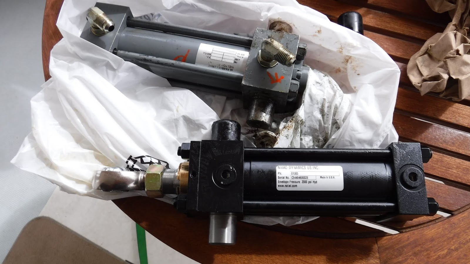
 |
| access to work on mechanism for port fin |
 |
| New (black) cylinder next to original (grey) cylinder |
Once we had a plan in place for the stabilizer fin issue we
took time to enjoy Clipper Cove and San Francisco.
Clipper Cove is between natural Yerba Buena
Island and man-made Treasure Island.
Back in one of the San Francisco boom times it was felt that good times
deserved a celebration so they dreamed up an international exposition.
About the same time the first Bay Bridge was
nearing completion and would use Yerba Buena Island as a point along its route
(it lands on one side of the island, tunnels through the island and then a
second section of the bridge completes the route).
Finally, Pan American World Airways needed an
airport for its sea planes as they were preparing for their famous China
Clipper service across the Pacific from San Francisco to Hong Kong. This all
came together in 1939 when the Golden Gate International Exposition opened its doors on newly
minted Treasure Island ( Click for:
Newsreel of the 1939 exposition )
 |
| New Bay Bridge from Clipper Cove Anchorage |
So we were anchored on one of the most famous aircraft runways in the
history of aviation, next to two huge hangers where Pan Am worked on its fleet,
and got our anchorage permit (free) from and office in the original
administration building from the world’s fair (the last 3 standing
buildings). I had to muse a bit that we
seem to have some strange connection with the flying boats. When we were in Sitka we often took a short
cut when we walked to the grocery store through a Turnaround Skateboard Park. The parking area for the park was a strange
circular concrete drive that looked like it had been part of a boat ramp at one
time. It wasn’t until I was looking at
some old photos adorning the walls of the Sitka Airport that I recognized the
circle under a passenger seaplane being readied to be sent back down the ramp
of the first Sitka Airport. Later we
were moored in Juneau Alaska and had lunch at a small café in the Auke Bay
parking lot. I got to looking at all of
the Pan Am photos on the walls and finally realized that the building was the
original Pan Am terminal for the Seattle to Juneau seaplane route. Hmmmm, I wonder where we will find our next
bit of Pan American World Airways history.
 |
(Source: Google Earth) Circle in the center is the original Sitka Airport
(Skate park is under the roof at the bottom left of the turnaround circle) |
CeGetting to downtown SF from Clipper Cove was easy as city
busses ran every 20 minutes. We would
take our dingy over to the marina where we had paid a small fee for daily
access to the locked facility and then walk 1 block to the bus stop. We rode the cable cars (fare has gone from 10
cents on our first visit to the city before we were married to $7 now and the
service and suffered considerably), and found the electric trolley cars to be
one of the most efficient ways to travel to and from the tourist areas. We took the ferry out to Alcatraz Island and
toured the prison where I found the foundations laid down during the Civil War
era to be fascinating. In the end we found the city to loud, noisy, expensive
and not particularly friendly. This was
a fun place to visit but we were ready to move on.
 |
| Cable car |
 |
| Alcatraz cell blocks |
 |
| looking towards Alcatraz wharf |
 |
| Civil War era construction Alcatraz |
 |
| Civil war construction on the lower levels Alcatraz |
 |
| staff housing Alcatraz |
From San Francisco we headed to the Channel Islands. Clarice’s personal sea monster was Point
Conception where the warm waters from the south meet the cooler waters from the
north and can be rather unpleasant. It
was. We planned to get into a cove on
one of the northernmost islands before dusk but arrived too late. The chart showed lots of rocks and the water
was snotty. The chart showed a cove on
the next island south that looked like it would be better protected. We called the coast guard who was able to ask
someone with local knowledge about the cove.
We were assured that with the current weather conditions (officially
small craft warnings with wind and waves from the north) we were likely to find
the cove to be a safe harbor for the night.
We pulled in next to a 200 ft NOAA ocean research ship that assured us
by radio that there were no rocks or other boats to worry about. They did advise that they had dropped a
second anchor because of the strength of the wind coming over the island (we
compensated by letting out lots of “Alaska proven” anchor chain).
The next day we anchored next to Santa Cruz Island and
headed ashore with Jarvis in the dingy.
On arrival at the beach we were told by the National Park personell that
dogs were not welcome on or off a leash.
Poor Jarvis had his mind set on getting his paws on land for the first
time in 2 days – he was pretty upset to be taken back to the boat. We were both tired and cranky but I
appreciated the issue a bit more when I spotted one of the indigenous , kitty
cat sized Santa Cruz foxes near the dock and knew that Jarvis would not be able
to keep quiet around his smaller cousin.
 |
Santa Cruz Fox |
To compensate Jarvis we headed to the mainland the next day
and took a mooring ball in Redondo Beach where we found plenty of places to
walk him (he even got to play on the sand beach one evening before we realized
that he wasn’t welcome there). Redondo
Beach is quite the tourist haven reminding us of our stay in Ocean City New
Jersey when are kids were quite small. There are lots of dedicated bike trails
and we rode for miles along the beach. The local paddle board, kayak, and
paddle boat concessions do a lot of business partially thanks to a raft
dedicated to the use of seals and sea lions.
We were on the path from the dock to the (VERY noisy) marine mammal float
and so Jarvis spent his days barking with wild abandon at human powered craft
as they passed by our mooring.
 |
| They added a day to Lobster Fest (Oct 1) and gave a special deal if you bought 2.... |
 |
| ....so we bought 2. |
 |
| Birds on the breakwater behind our mooring ball. |
 |
| Marine mammal barge and tourist in a paddle boat |
 |
| Pelicans on the inner breakwater (there were hundreds of them!) |
After leaving Redondo Beach we made a short run to Dana
Point where Nordhavn company headquarters are located. Several years ago I read
Two Years Before the Mast by Richard
Henry Dana and found the book about his journey which began in 1835 to be
fascinating. Books of sailing ships of
the era were pretty much all written by the ships officers who never ventured
below deck. Dana was the exception as he
was college educated (eventually becoming a lawyer specializing in defending
seafarers) but was losing his vision and fresh air was the recommended
treatment. He chose to sign on as a
seaman aboard a trading ship headed to California. In the beginning, as a greenhorn, he was
given a berth near the rudder (in steerage) but eventually earned his place
before (in front of) the mast (which was wet and much more uncomfortable but an
honor none-the-less). In California they
traded off the goods they had carried with them and then collected cow hides
from the local ranches which were tossed off the cliffs onto the beach to save
carrying them down the hill. Once they were
ready to leave they loaded their ship the Pilgrim
until the timbers literally were swollen with the load. They headed out to Magellan’s Strait in June
which put them in the strait in the middle of the southern winter. As I recall it took them a month with ice
covered rigging (and the loss of one of the eight crew members overboard) to
get through the strait. By the time they
got north to the Caribbean one the of the remaining crew members was in quarantine
with scurvy (which was dreaded and believed to be contagious). A local brought a load of onions to the boat
in a dugout canoe and they were amazed at how good they tasted raw (background:
scurvy is caused by a lack of vitamin C in the diet, onions are a great source
of vitamin C) and how quickly the crew member was cured of scurvy “by the warm
air” and back at his post. Dana Point is
where the ship loaded the hides and is named in honor of the author.
 |
| A replica of the Pilgrim |
 |
| Richard Henry Dana |
 |
| Cliffs where the skins were thrown to the waiting crews below |
On arrival in Dana Point we walked over to the Nordhavn
office and collected our stabilizer parts which had been mailed there for us.
The parts took about 10 hours of work but are now installed and seem to be
working well. The silver lining in all
of this is we knew we had one of the early boats with “undersized” cylinders
and hydraulic pump. The cylinders we had
were long out of production and even with new shaft seals one of them always
leaked a tinsy bit of oil. In summary this has long been a project on our
priority list but as they were working the way they were and would cost about
$2500 to upgrade the swap had remained at the bottom of the priorities. With a broken shaft they moved to the top of
the list and I’m convinced are now moving the fins more effectively than in the
past.
We arrived in Dana Point on a Tuesday and had been told we
were invited to a pizza lunch so we could meet the staff. Nordhavn is one of the most customer focused companies
we have ever encountered. We may have
one of the lowest value boats with their brand name on it but they treated us
royally. While there we were awarded our
10,000 mile banner and given logo shirts and jackets. (A bit of foreshadowing here: we were also
told that a great honor among Nordhavns may
be coming our way.)
 |
Dan Streech of Nordhavn presents us with our 10,000 nm pennant
(photo credit: Nordhavn/PAE) |
We are now approaching San Diego Harbor where we expect to
lay for the rest of the month. So I will sign off and get ready to prepare for
landing.


